Project Objectives
- Identify high value habitat for each of the three types of caribou in the MRB.
- Value and identify resource reserve locations.
- Design a reserve network based on the results form objectives 1 and 2.
Full results are included in our final paper, which is available at the bottom of this page. The following descriptions are meant to give brief summaries of our results.
Results
Objective 1: Identify high value caribou habitat
We used three separate methods to define high value caribou habitat. First, we used current range maps created by the Canadian Government. Second, we used MaxEnt (a species habitat distribution software) to identify the bio-climatic variables most closely representative of current caribou ranges for each of our three caribou species of interest. Third, to determine how current caribou ranges would shift as a result of climate change, we projected the occurrence of the same environmental variables under 2 different carbon emission scenarios out to 2050.
We then combined all of these results - the current ranges, the current areas with good environmental characteristics , and the future areas with good environmental characteristics - to find where the highest value caribou habitat exists now and into the future.
We then combined all of these results - the current ranges, the current areas with good environmental characteristics , and the future areas with good environmental characteristics - to find where the highest value caribou habitat exists now and into the future.
Objective 2: Value resource reserves
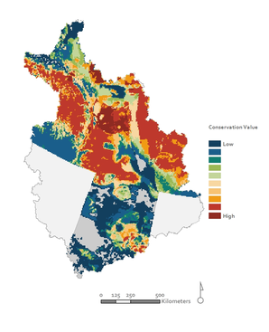
We worked with the territorial and provincial governments of Alberta, Yukon, and Northwest Territories to identify the locations of all natural gas, oil, mineral, and commercially viable timber reserves within the MRB. The vast majority of resource extraction within the MRB is taking place in Alberta, where sawmills, pipelines, and refineries are all heavily developed and consumer markets are more accessible.
The most valuable minerals within our study area include diamonds, gold, and precious and industrial minerals like lead, silver, and tungsten. Regarding oil and natural gas, the largest oil reserve is the Athabasca and Peace River oil sand areas in eastern Alberta, while the most valuable natural gas areas are the geologic formations of the Western Canadian Sedimentary Basin in western Alberta. The map below shows land value, in millions of US Dollars, when we combine the individual resource values together.
The most valuable minerals within our study area include diamonds, gold, and precious and industrial minerals like lead, silver, and tungsten. Regarding oil and natural gas, the largest oil reserve is the Athabasca and Peace River oil sand areas in eastern Alberta, while the most valuable natural gas areas are the geologic formations of the Western Canadian Sedimentary Basin in western Alberta. The map below shows land value, in millions of US Dollars, when we combine the individual resource values together.
Objective 3: Design reserve networks
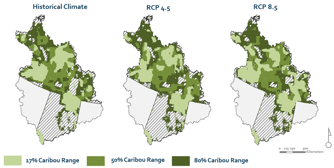
Once we identified the most important areas for caribou and the most important areas for resource industries, we were able to design cost effective reserves which maximized caribou habitat protection and minimized economic losses. The conservation planning software, MARXAN, was used to accomplish this goal. Conservation targets were set to percentages of caribou ranges for each of our three target caribou types. We initially analyzed three specific targets: 17%, 50%, and 80% of caribou ranges. The reserves which were created under these targets allowed us to identify two important features:
1) Where the reserves would be located.
2) How much each of these reserves would cost.
As previously mentioned, we also projected future caribou ranges under two different carbon emissions scenarios; which we will call RCP4.5 and RCP8.5 (for more information on these emissions scenarios please see the final report attached at the bottom of the page). To determine if these reserves would shift in cost or location due to these changing caribou ranges, the process was repeated for each emissions scenario. The results of our analyses are shown below.